View GPS Information
Note: If Implement Steering is available, verify the Implement Steering GPS in addition to the machine’s GPS.
To access GPS information:
- Select Settings
 on the bottom left of the Home screen. The Settings Menu will open.
 -
Select GPS
 on the Settings menu.
Note: GPS Settings can also be accessed by the Status Card on the top-left corner of the home screen and run screen.
- Select the DIFF
 tab to view and select GPS Differential
 Differential Global Positioning System is an enhancement to standard GNSS/GPS messages to provide better position accuracy. Setup information such as available differential Differential Global Positioning System is an enhancement to standard GNSS/GPS messages to provide better position accuracy. Type and PRN Pseudo-Random Number.
Note: It is recommended to keep differential
Differential Global Positioning System is an enhancement to standard GNSS/GPS messages to provide better position accuracy. settings set to Auto unless directed otherwise. - Select the PORT A
 tab to view and edit information on the GPS: Port A Configuration screen. If desired, select additional port tabs to view and edit GPS information for those ports. In some cases Port may be referred to as COM.
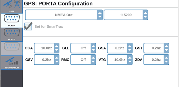
Note: Port A is not configurable.
- Select PORT B tab to configure a generic GPS receiver. Generic GPS NMEA National Marine Electronics Association Out must have the following settings:
GGA at 10hz
VTG at 10hz
ZDA at 0.2hz
Optionally, the follow settings are allowed:
GSA at 0.2hz
GST at 0.2hz
GSV at 0.2hz
A baudrate of 115200 is highly recommended.
Note: The radar out is always functioning when a GPS receiver is detected, and pulses at 45 Hz per 1 mph or ~27.5 Hz per 1 kmh or ~100 Hz per meter.
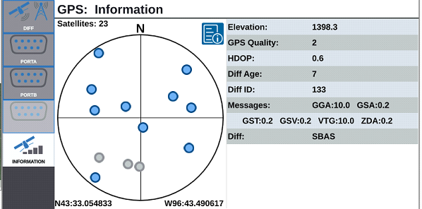
- Select the INFORMATION
 tab to view information on the number of satellites visible, Elevation, GPS Quality, HDOP Horizontal Dilution of Precision, Diff Age, Diff ID, Messages, and Differential Differential Global Positioning System is an enhancement to standard GNSS/GPS messages to provide better position accuracy. type.
Note: The image below shows an example of what a GPS satellite array may look like above an implement. The blue dots are GPS satellites current being used for corrections. The GPS satellites that are grayed out indicate satellites not being used for correction.
- Select Accept
 to save the displayed settings and return to the Settings menu.
Last Revised: Mar 2025