Maps Area
The map displays the last reported position of each Slingshot® enabled device associated with the user account.
Use the on-screen controls to change the map view as desired.
Full Screen
Select the View Full Page button in the upper, right corner of the map to view a large scale map.
Note: Use the browser Back button to return to the home page.
The following options are available while viewing the map in full screen mode.
Base Radius
Enable this option to display the radius of each base station associated with the account.
Note: Slingshot® base stations have an effective radius of 48 km [30 miles].
Baselines
Displays a straight line between the Slingshot® base stations and any Slingshot® devices associated with the base station.
Slingshot® Field Hubs
Display all Slingshot® Field Hubs associated with the user account.
Layers
Use the layers button in the upper, left corner to toggle the map between a street map and a satellite display.
Note: The street map view provides simple terrain features.
Devices
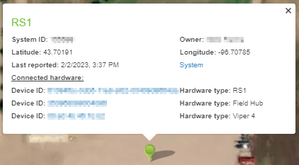
Select the balloon representing the location of any Slingshot® enabled device to view device information.
The details include:
- Slingshot® enabled system ID number.
- Slingshot® enabled device owner.
- Latitude and longitude.
- Date and time which the system or device last reported position data to the Slingshot® server.
Note: Use the System or Device ID links to open the System information page directly from the map view for the selected system. To view all systems, open the Manage menu and select Systems.
System Link
Select the System link to review information on devices connected to the system, update software versions, and other system details.
Base Stations
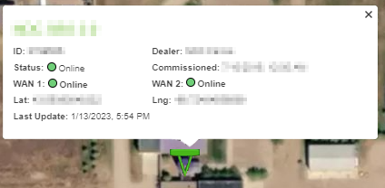
Base Stations associated with the account are displayed on the Home page map with a triangular symbol to show their position and status.
Status of the base station will be presented as:
-
 Green Dual (WAN 1 and WAN2) internet connections
 -
 Yellow Single internet connection
 -
 Red Offline
Select the icon representing the location of any Slingshot® base station to view device information.
Note: Both internet connections, WAN 1 and WAN 2, will display independent connection status (green - online, red - offline).
Note: The Commissioned field displays the date and time which the last 24-hour survey of the base station location was completed.
Last Revised: Sep 2024


